
In order to get a better visualization of the 3D cloud information, AWT developed a web interface that allows for better interrogation of the data. The web interface displays the post-processed gridded output from various model guidance options including three cloud bases and corresponding sky coverage for each forecast hour from the the latest several model runs, as well as the model derived ceiling and visibility. In addition to the single layer look at the information, the tool allows for creating point-and-click TAFs as well as cross-sections of the cloud layer information along a path.
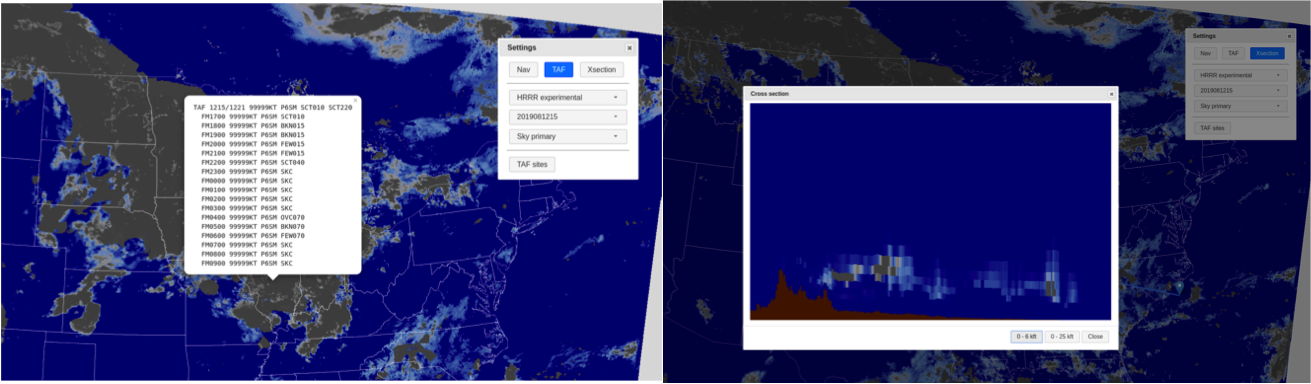

After day one, it was clear that the cross-section ability has several advantages and could be useful for multiple users. While it may not be the primary tool used to forecast ceilings, they could prove beneficial to bolster confidence in a cloud layer occurring or in seeing a thin low cloud deck or fog. Forecasters may not have the time to look through multiple cross sections for multiple forecast hours, however they could use it to confirm a secondary layer or get a better idea of what the model is trying to tell them in terms of the cloud development. However, pilots may find the tool extremely useful for planning along a flight path, especially if there could be a time element added in which conditions match the time in which they expect to be flying through that region.
In terms of model performance thus far, participants have been impressed with the HRRRx cloud placement in the vertical more accurately hitting the cloud bases and coverage. This verified well on Day 1 with the stratus off the coast of California and cloud placement in the north east associated with late afternoon convection. Overall, so far it seems the guidance tends to agree with cloud occurrence and conditions, but differ on timing and placement.
 |
| The experimental HRRR cloud base primary indicating low ceiling moving into the Sacramento valley via the delta breeze. |
Evaluations will continue through the week with specific areas of focus being determined each morning based on impacts for that day and the next.
menurut saya semua yang kalian lakukan itu tentu saja terbaik dan sudah semampu nya untuk membantu banyak orang di dunia ini terima kasih untuk kalian semua.
ReplyDeleteProses daftar togel online di nero4d resmi sudah tentu sangat mudah sekali karena, mitra kami yang tersebar di indonesia itu sudah banyak bukan hanya itu saja. Untuk marketing atau admin yang selalu update di sosial media dan selalu memberikan prediksi togel online, sudah tentu akan memudahkan kalian untuk bisa menang dan merasakan JP besar atau kemenangan jadi tunggu apa lagi segera klik link ini: http://151.106.113.115/register.php