Monday, February 8, 2016

Impact-based Decision Support Services (IDSS) at work - first CAWS for turbulence!

20160208 - 001 FINAL

CAWS Image
Collaborative Aviation Weather Statement 001
NWS Aviation Weather Center Kansas City MO
1525 UTC Mon 08 Feb 2016

Weather: Turbulence
Valid: 1800-2200Z

ARTCCs affected: ZFW, ZHU, ZME
Terminals affected: KDFW

SUMMARY: MOD-SEV TURB Probable over Eastern TX and Northern LA

DISCUSSION: Moderate to Severe Turbulence is probable between 18Z and 22Z across Northern TX and Northern LA. Area will continue to be monitored for SIGMET issuance.

Area expected to move east-southeastward after 22Z so additional CAWS statements are possible.

BOUNDING BOX: 34.86,-98.98 33.94,-89.45 30.34,-89.82 30.46,-99.05 34.86,-98.98

And we're off!

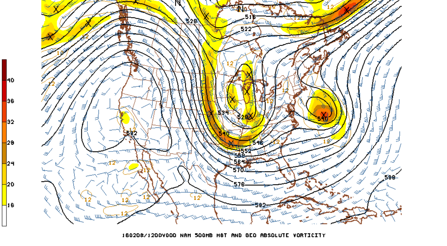
The interesting weather for the next few days will be over the eastern half of the country thanks to the midwest low pressure system with several intense shortwaves rotating around it. 
Feb 8 12Z NAM 500mb ht abs vort

Feb 9 12Z NAM 500mb ht abs vort


Friday, January 29, 2016

Winter Weather Experiment

The second ever Aviation Weather Winter Experiment will kick-off on Monday, February 7th at 8:00 am in the Aviation Weather Testbed! Please visit the 2016 Winter Experiment webpage for information on data sets, displays, and tools that will be utilized during the experiment.

Thursday, August 13, 2015

A "Perfect" CAWS?

With little convection impacting the NAS yesterday afternoon the forecasters had time to review an archived case of a particularly impactful day. The forecaster looked at the CAWS graphics created on June 18, 2015 for areas being impacted by the remnants of tropical cyclone Bill. The forecaster was tasked with creating a "perfect" CAWS with the knowledge of how the weather evolved during the day. They looked at CCFP, INSITE, radar data, and the CAWS graphics from that day. Again, different colors, polygon fills, and arrows were used to see if more information could be conveyed in the graphic without becoming too cluttered.

Wednesday Morning CAWS Production


Yesterday was not as impactful of a weather day in terms of convection. The CAWS forecasters did focus some time in the morning to issue CAWS for convection off the coast of the Carolinas and a CAWS for convection impacting the Jacksonville, FL vicinity. The forecasters experimented with different colors and polygon fills. The fills are used to indicate coverage while the different color text box highlighted peak time of impact.  Any thoughts on these techniques?


Tuesday, August 11, 2015

Day Two--Testing Out New Techniques

We are on Day Two of the Summer Experiment! Now that we are more oriented with desk tasks and goals we are experimenting with new techniques. For example, the CAWS forecasters are trying out the effects of changing the line weight and color on the graphic. On the first image below, the use of a bolder line indicates higher confidence. On the second image, a different color (pink) is used to indicate when the greatest impact to the terminal would be.

Monday, August 10, 2015

The Summer Experiment has Kicked-off!

Today is the first day of the 2015 AWT Summer Experiment. We are very excited to host a wide range of visitors from the FAA community, NOAA, academia, and Industry. The first part of the morning focused on getting familiar with the different experiment desks and tasks. By mid-morning our CAWS production desk and support desks were delving into today's impacts while the Ceiling and Visibility desk and Tropical Graphics desk began working on their products.  So far, two CAWS graphics have been issued. One is for the Ohio Valley for later on this afternoon and the second one is for impacts to Atlanta.