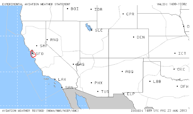
It is a relatively quiet morning in the NAS. Two main areas of focus are SFO with low ceilings and visibilities and the mid-Atlantic states with ongoing and developing convection. Below are the experimental Aviation Weather Statements and forecasts out of the testbed this morning.
Friday, August 23, 2013
Winding Down in the Testbed
Today is the last day of the 2013 AWT Summer Experiment. However, this does not mean our work is done! We will be collecting all the feedback, comments, and notes from the past two weeks so that we can evaluate the data sets, products, and overall experiment. We greatly appreciate all the hard work and dedicated efforts that resulted in a successful experiment.
It is a relatively quiet morning in the NAS. Two main areas of focus are SFO with low ceilings and visibilities and the mid-Atlantic states with ongoing and developing convection. Below are the experimental Aviation Weather Statements and forecasts out of the testbed this morning.
It is a relatively quiet morning in the NAS. Two main areas of focus are SFO with low ceilings and visibilities and the mid-Atlantic states with ongoing and developing convection. Below are the experimental Aviation Weather Statements and forecasts out of the testbed this morning.
Thursday, August 22, 2013
Afternoon Look
Below is the verification of the 16 UTC 2-hour experimental CSIG Convective Outlook valid at 18 UTC.
Light blue areas are 2-hour convective outlooks, red/blue/yellow areas
are operational convective SIGMETs (red=0hr, blue=+1hr, yellow=+2hr),
green areas are operational convective 2-6hr outlooks, composite
reflectivity is shown in grey-scale and filled contours are Earth
Networks Total Lightning 10-min density
Focus on the Northeast
The AutoNowCaster forecast shows increasing instability in the eastern part of the US (issued at 1554 UTC and valid at 1654 UTC).
Latest ASDI and Reflectivity
Echo Tops at 16 UTC (from CoSPA website)...
Active weather in the Northeast has prompted the issuance of the AWS below.
What is going on this morning across the US?
Today is a bit more active across the NAS (mainly in the northeast US) than we have seen over the past couple of weeks. Stay tuned as the weather and forecasts evolve over the next several hours!
Below is the experimental 2-hour CSIG Outlook issued at 14 UTC and valid at 16 UTC.
Here is a base reflectivity image overlaid with ARTCC boundaries from SPC's mesoanalysis page.
Below is the experimental 2-hour CSIG Outlook issued at 14 UTC and valid at 16 UTC.
Here is a base reflectivity image overlaid with ARTCC boundaries from SPC's mesoanalysis page.
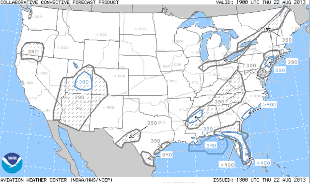
Operational 4-6-8 hour CCFP...
Wednesday, August 21, 2013
Mid-Morning Update
Below is NCAR's experimental HRRR time-lagged ensemble-based Large-Scale Convective Storm Likelihood (filled contours) and Large-Scale Convective Storm-Convection Initiation Likelihood (green contours) issued at 15 UTC and valid at 22 UTC. The products depict the likelihood of LCS and LCS-Convection Initiation being within 125 km and 1-hour from valid time.
Below is the HRRR Convective Probability Forecast Product -- 5-hour forecast valid at 17 UTC.
Below is the HRRR Convective Probability Forecast Product -- 5-hour forecast valid at 17 UTC.
This is the latest 2-hour Experimental Convective Outlook valid at 17 UTC.
What's in Store for Today?
Weather across the CONUS is a bit more active this morning than it has been over the past week. Below are a few forecasts that show potential areas for thunderstorm evolution through this morning.
Here is the 2-hour experimental Convective Outlook valid at 16 UTC. Majority of thunderstorm potential looks to be contained in the southeast.
The Extended Convective Forecast Product created from SREF calibrated thunderstorm depicts areas of thunderstorm probabilities. The ECFP forecast for the first part of the day highlights the southeast for greatest probability of thunderstorms.
Here is the 2-hour experimental Convective Outlook valid at 16 UTC. Majority of thunderstorm potential looks to be contained in the southeast.
The AutoNowCaster forecast for this morning continues to show low probability of thunderstorm initiation across the CONUS. It does, however, highlight portions of the southeast for fostering a more favorable environment for thunderstorm development. We will monitor how the atmosphere evolves in this area for potential NAS-impacting weather.
ANC forecast valid at 1414 UTC.
Here is the operational 4-hr CCFP valid at 17 UTC.
Tuesday, August 20, 2013
Afternoon Updates and Forecasts
Below is the verification of the 17 UTC Experimental Convective Outlook valid at 19 UTC.
Light blue areas are 2-hour convective outlooks, red/blue/yellow areas
are operational convective SIGMETs (red=0hr, blue=+1hr, yellow=+2hr),
green areas are operational convective 2-6hr outlooks, composite
reflectivity is shown in grey-scale and filled contours are Earth
Networks Total Lightning 10-min density
Here is the experimental Convective Outlook valid at 21 UTC.
Below is the latest AutoNowCaster forecast issued at 1834 UTC valid at 1934 UTC.
So where's the focus for this afternoon?
Here's the Experimental CCFP valid at 19Z today...
Here's the experimental 2-hour convective outlook valid at 19Z
Here's the experimental HRRR convective probability forecast (8-hour fcst) valid at 19Z today ...
Here's the AutoNowCaster forecast issued at 1634 UTC valid at 1734 UTC. This is one piece of information the CSIG forecaster had when creating his outlooks valid at 19Z.
Here's the CoSPA forecast valid at 1910 UTC, issued at 1640 UTC...
Verification of experimental 2-hour convective outlook valid 21Z Aug 19
Monday, August 19, 2013
WEEK 2
Still very little thunder forecasted for this week, but we'll work with what we have. Below is the ANC forecast at 1638 UTC today, valid at 1738 UTC.

Here's the experimental 2-hour convective outlook issued at 1655 UTC valid at 1900 UTC:
Here's the Experimental CCFP forecast issued at 1529 UTC valid at 1900 UTC:

Here's the experimental 2-hour convective outlook issued at 1655 UTC valid at 1900 UTC:
Here's the Experimental CCFP forecast issued at 1529 UTC valid at 1900 UTC:
Friday, August 16, 2013
Where's the thunder???
Unfortunately we have a very quiet day today. Here's the operational Convective SIGMETs issued at 1855 UTC
18Z Convection
This graphic shows the experimental 2-hour convective outlook issued at 1555 UTC valid at 18Z overlaid on the operational convective SIGMETs, base reflectivity, and NLDN data all valid at 18Z.
What's today's convective story going to be?
Here's the surface analysis valid at 15Z
What are the high-res models saying? Here's the AFWA probability of composite reflectivity >= 40 dBZ valid at 18Z (6-hour forecast)
Here's the HRRR composite reflectivity valid at 18Z (5-hour forecast)
What are the high-res models saying? Here's the AFWA probability of composite reflectivity >= 40 dBZ valid at 18Z (6-hour forecast)
Here's the HRRR composite reflectivity valid at 18Z (5-hour forecast)
Thursday, August 15, 2013
Operational CSIGs overlaid on Experimental NSSL 4km Lightning Threat
Experimental Convective SIGMETs versus Operational Convective SIGMETs
Subscribe to:
Comments (Atom)


