Wednesday, June 26, 2024

Taking a look at how AWC forecasters can provide decision support to the GA community

Aviation Weather Center has continuously received feedback from their pilot partners that they would like to have an easy to interpret, quick glance graphic that gives them an idea of what hazards to expect in the coming days. Testbed participants are tasked with developing sample graphics for both a “Key Aviation Message”, similar to the Key Messages developed by local forecast offices, and Days 2 and 3 outlooks for aviation hazards.

Participants looking at various data products to develop outlook graphics

The goal of the Key Aviation Message is to communicate an impactful weather event occurring in the NAS that may cause general aviation (GA) pilots the need to alter their flight plans. These decision support graphics are intended to be sent out a couple times a day, for this experiment specifically testing once in the morning for the day of events, and a separate graphic in the afternoon or evening covering a major area of concern for the following day. A big aim for our participants this week is to help hone in on what information is important to share with pilots and how we can help local weather forecast offices (WFO) share aviation hazards. Participants reiterated the importance of using plain language and focusing on our GA pilot audience for flight levels and impacts. A couple other ideas participants noted were the importance of including a valid time or next issuance update time, and using local time vs zulu. The WFO participants mentioned sharing the graphics on their social media, in addition to AWC social media, if their area is impacted to help reach a larger audience!

Sample Key Aviation Message outlining icing conditions in the Pacific Northwest

One of the most repeated requests from GA pilots is for a longer term outlook at what the weather may look like in the next couple days. AWT has taken a look at outlook graphics which cover the day 2 and 3 time frames in the past and have come up with some questions about how to show this larger temporal resolution graphic, identifying what aviation hazard criteria must be met in order to be included, and how to provide this quick glance first look. This experiment, our participants created three separate graphics to show these hazards out to day 2. The day 2 (next day) outlook was divided into a morning and afternoon/evening forecast, and day 3 covered the entirety of the daytime flying.

Sample Day 2 PM Outlook graphic drawn by participants and overlaid with fronts

Guidance was provided for criteria which must be met for each aviation hazard, based on standards for GA pilots. As participants drew their outlooks, internal discussions covered the importance of having two separate day 2 graphics and how useful this additional outlook will be for GA pilots looking to plan out in the next couple days. Some ideas for AWT to further investigate include the possibility of adding text information, constraints of layer colors or outlines, or additional toggles when they are displayed on the website. As we continue to solidify how these outlooks may look, the next big step will be to get the graphic in front of users to really assess the intuitiveness and utility of the product for its intended users!

Monday, June 24, 2024

AWT Summer Experiment 2024 Starts Tomorrow!

The AWT welcomes a new set of guests back for the second experiment of 2024. This three day 2024 AWT Summer Experiment will run from June 25-27th in the Aviation Weather Center Testbed. As the second of two experiments this year; AWT is continuing on from the RRFS evaluation this spring, one desk is focusing on new convective products and working in collaboration with the National Severe Storms Laboratory (NSSL) the kick off the Warn on Forecast System (WoFS) assessment with our CWSU partners, and the other focus area will be taking a look at how another future new AWC forecast desk may bring further collaboration for aviation within the National Weather Service.

Testing out new outlook graphics in AWIPS to display on the testbed website

Visitors from various Center Weather Service Units and Forecast Offices, National Severe Storms Laboratory (NSSL), Space Weather Prediction Testbed (SWPT), Meteorological Development Laboratory (MDL), FAA Aviation Weather Demonstration and Evaluation Services (AWDE), NCEP Social Science, Univ. of Oklahoma, and Southwest Airlines will be here to provide valuable input and share new ideas.

The WoFS drawing tool in action

Thursday, April 4, 2024

Enhancing collaboration between AWC and Core partners

There is a growing emphasis on improved collaboration and communication regarding anticipated aviation hazards to ensure a uniform aviation forecast across the National Weather Service (NWS). Participants at the AWT Spring Experiment are navigating what this collaboration may look like as a new forecast desk, National Aviation Operations Center (NAOC), within the operations at AWC.

Throughout the week, participants are simulating some of the tasks that may be done by an AWC lead forecaster at the NAOC desk and providing feedback based on the utility of the collaboration for their own operations. One major task for the forecasters is to develop and conduct a mock national collaboration call targeted for internal NWS aviation forecasters to ensure we are drawing the same picture regarding weather impacts to the NAS. Utilizing a new “briefing tool” on the testbed website, our participants collected the information they thought would be most useful for our CWSU partners and presented a mock call. Participants discussed the timing of these calls and how they might affect our partners differently from mornings on the east coast in the swing of things to the west coast still waking up.

AWC lead forecaster Joey Welsh working on creating a collaboration call briefing package

Participants are also exploring how AWC might create a decision support graphic depicting the “Key Aviation Message” of the day. This graphic is aimed towards providing general aviation pilots a targeted picture of major impacts within the NAS. While exploring different tools to create a graphic, the participants spent time honing in on what they considered the most major impact and how to relay this information to the GA community.

Monday, April 1, 2024

AWT Spring Experiment 2024 is Ready to Welcome Guests

Tomorrow starts the first day of the 2024 AWT Spring Experiment. This year the AWT is running two different “mini” experiments, one in the spring and one in the summer, in order to separate the different areas of focus and really hone in on each focal point. This spring, the AWT is welcoming meteorologists from various Center Weather Service Units and Forecast Offices, Global Systems Lab (GSL), Alaska Aviation Weather Unit (AAWU)/Alaska Region, Environmental Modeling Center (EMC), Southwest Airlines, and the FAA Weather Division to assist in assessing products and offer valuable insights and expertise.

GTG data available on the testbed webpage with an example G-AIRMET overlaid

This spring the participants will have two main areas of focus: evaluating the Rapid Refresh Forecast System while creating experimental G-AIRMETs on the testbed website, and providing insight on how AWC can enhance their collaboration to core partners by investigating the viability of a National Aviation Operations Center (NAOC) desk deployed within operations at AWC.

AWC Forecaster providing weather information for aviation partners

Thursday, May 18, 2023

AWT Takes Over FPAW

Stakeholders from across the aviation community are in Kansas City this week for the Spring FPAW (Friends and Partners of Aviation Weather) meeting. Today, AWT integrated with FPAW to leverage knowledge and thoughts from users and producers of aviation weather information. The primary focus today was evaluating user interpretation of probabilistic aviation information. Through online polling and discussion, users were able to provide insite on aviation probabilistic products.
AWT presents at FPAW

This morning, we started with an overview of the winter weather dashboard; which is an operational product both on aviationweather.gov and experimental on our beta website. FPAW participants appreciated the demonstration of the dashboard and being able to see plume and model trend data. They also expressed interest in more information on the impact thresholds on the dashboard.

After lunch, FPAW broke into groups to discuss non-deterministic methods for communicating aviation hazards. Utilizing some of the probabalistic desk graphics the testbed participants have been working on during the week, we got a lot of feedback on how the data are presented and how different weather phenonemon impact the general aviation community. Some of the "hot topics" from the participants were focused on how detailed the graphics are or should be, spatial coverage of the polygons, and how pilots versus meteorologists perceive data.
AWT Organizer, Jack Lind, leading discussion on probabilistic graphics

The day wrapped up with a look at the outlooks graphics from last years 2022 AWT Summer Experiment. Good discussion on the time scale of the outlooks, the busyness of a map with all aviation weather impacts, and how adding text to the graphic would enhance an outlook helped AWT hone in on some of the things the general aviation community is looking for in an outlook graphic.

Wednesday, May 17, 2023

2023 AWT Spring Experiment in full swing

The AWT is hosting meteorologists from across the country for our spring experiment! This week, participants from the Meteorological Developement Lab (MDL), Global Systems Lab (GSL), FAA Aviation Weather Demenstration and Evaluation (AWDE), Alaska Aviation Weather Unit (AAWU)/Alaska Region, Honolulu Forecast Office (HFO)/Pacific Region, and various Center Weather Service Units and Forecast Offices are here to help evaluate products and provide their insite and expertise.
Participants diagramming workflows for Hazard Services
There are three areas of focus this year: evaluating the 3-dimensional cloud forecasts from the RRFS, creation and discussion of prototype probabalistic graphics and how to present information to the general aviaiton community, and developing and evaluating workflows for Hazard Services for aviation.
Using various resources to create probabilistic forecasts

Thursday, September 15, 2022

A Look at Developing Outlooks for General Aviation

One of the major themes, or desks, of this year's experiment is looking at the potential for creating Outlook Graphics for Days 1, 2, and 3 for AWC's General Aviation (GA) customers. Current AWC operational products do not go out beyond Day1, leaving an information gap (Fig.1) for those that are looking to plan for flights in the coming days. AWC has continuously received feedback from their pilot partners that they would like to have an easy to interpret, quick glance graphic that gives them an idea of what hazards to expect in the coming days.


Fig1. Current aviation weather forecast gap at the Aviation Weather Center for aviation hazards.

Experiment participants were tasked with developing Outlook Graphics that would be valid 12z-12z the following day and depict prolonged, impactful hazards which could include turbulence, IFR, icing, precipitation, smoke, and thunderstorms. The design would be similar to the current National Forecast Charts (Fig2) developed by the Weather Prediction Center, and maintain consistency with existing NWS products (ie. WPC, NHC, NDFD).  Participants used an interactive drawing GUI on the Testbed Website that allowed them to overlay fronts, modify the background map, and draw various polygons for each forecasted hazard.

Fig2. An example of the Weather Prediction Center's National Forecast Chart for Day1.


While ultimately user input will be critical for determining the utility of the Outlook graphics, participants were asked to fucus on things like the design, what guidance to use, what hazards were most impactful and should be included, and the overall workload that would be associated with creating such a graphic. It was clear from day one of the experiment that everyone brought different perspectives and ideas to the table, leading to an active and fun desk throughout the week.

Fig3. An example of one of the Outlook Graphics created during the experiment.


Throughout the week all participants agreed that determining the severity and impact of the graphics for the GA community will be the top priority before moving forward with operationalizing the product. Participants also indicated that a more detailed summary of the impacts with location and timing associated with them would be beneficial for Day1 for both GA fliers and fellow meteorologists. Other ideas that were brought up were the potential for multiple outlook 'tabs' for the various user types (GA, Low Altitude (LA), and National Air Space (NAS) planning), or even breaking up Day 1 into two separate Outlook graphics (morning and afternoon) to account for hazards that are only impactful during those periods.

In the end, the AWT staff recieved an abundance of perspective and ideas for moving the Outlook Graphic further toward operations. The next step will be to get the graphic in front of users to really assess the intuitiveness and utility of the product for its intended users.


Wednesday, September 14, 2022

AWT Summer Experiment Beta Website

Along with the evolution of the Traffic Flow Management Convective Forecast and creation of new prototype multi-day outlook graphics, the participants are evaluating the Aviation Weather Center's new experimental website, beta.aviationweather.gov. AWC developers are in the testbed this week to help answer questions, and learn more about how the website is used in operations. 

The AWC Testbed page has been updated to the new look and feel of the beta website and participants are testing new products and ideas using the website this week! Prototype outlook graphics and convection forecasts are drawn on the website and saved as part of the evaluations.

Participants using the new testbed page to create prototype multi-day outlooks

Welcome to the AWT 2022 Summer Experiment!

The 2022 AWT Summer Experiment kicked off on Tuesday with a full house of collaborators and stakeholders from multiple entities of the aviation weather enterprise. Participants include developers from NOAA’s Earth System Research Lab (ESRL), and NCEP’s Environmental Modeling Center (EMC); meteorologists from AWC, Center Weather Service Units (CWSUs) and Weather Forecast Offices (WFOs) from across the country, and Southwest Airlines; as well as researchers from the Weather Prediction Center (WPC) and the National Severe Storms Laboratory (NSSL).

After a few years of primarily virtual testbed activities, the Aviation Weather Testbed and AWC are excited to welcome participants back to Kansas City for this collaborative evaluation.

Participants discussing the Warn-on-Forecast System (WoFS)


There are two major themes this year: evolution of the Traffic Flow Management Convective Forecast and creation of new prototype multi-day outlook graphics. Participants will be utilizing experimental model guidance and tools this weeks, exploring ways to improve existing products and potentially create new ones.

Reviewing medium range guidance for the production of multi-day outlooks


Thursday, August 13, 2020

AWDE Services Gathers Probabilistic TCF Feedback


The Aviation Weather Demonstration and Evaluation (AWDE) Services team provided support to the
Aviation Weather Testbed (AWT) during the two-week, all virtual, 2020 Summer Experiment. AWDE
conducted interviews with twenty-one participants to collect feedback concerning the capabilities
incorporated into the probabilistic TCF product. Participants included CWSU meteorologists, PERTI team
members, one MIC, and one NAM. All participants attended 30-60 minute virtual interviews and
provided valuable feedback concerning the operational suitability and usability of the probabilistic TCF
product.


AWDE team members asked participants questions concerning the overall usability, how the products
capabilities would add value in an operational environment, and what would improve the product’s
suitability and usability. All participants gave feedback stating the product is a good first-look graphic
that provides an overview of convective regions nationwide for planning. This graphic would be used
alongside models to compare convective focus areas for planning. Additional overlays such as ARTCC
boundaries, jet routes, and airport locations would be useful. While the product provides a 24 hour
convective forecast, most participants would benefit from smaller time increments, such as three or six
hours, and be able to focus in on certain regions/areas. The ability to overlay MRMS and the final TCF
polygons as verification provided more confidence in using the probabilistic TCF product to identify
convective weather areas.

Overall, the consensus among participants is that the product would be used as an initial tool to identify
convective areas to focus on before analyzing more regionalized areas for day one planning.

Tuesday, August 11, 2020

Verification and Reliability of Probabilistic Information

When evaluating a product to determine it's usefulness, it is important to know how well it is performing. Verifying probabilistic information is a tricky problem. It's much easier to validate a deterministic product by looking at observations of what occurred. For this evaluation, we're offering two methods for users to utilize to look at how well the probabilistic information performed. 

The first option allows for overlaying “observed” TCF polygons on past runs. These polygons are generated from MRMS reflectivity and echo tops over the entire 24 hour period. This verification product is available on the AWC main website via the TCF page. To get a sense of what these polygons look like with the corresponding MRMS reflectivity, check out the graphic below. 

An example of the MRMS polygon verification product, showing how the polygons are generated around MRMS reflectivity that meets the TCF criteria.

The MRMS option is intended to serve as a subjective verification, of sorts, comparing how the guidance performed against observations. The polygons are color coded by valid times that occur during the 24hr period represented by the guidance probability contours. An example of what this looks like can be seen in the graphic below, with the MRMS generated polygons overlaid on top of a past HRRRe 24hr graphic.

An example of the TCF probabilistic HRRRe 24hr graphic overlaid with "observed" MRMS polygons from the same time period. 

Another way users can get a sense of how well the probabilistic product performed is by overlaying the final 4-hr TCF polygons generated by the AWC forecaster throughout the 24hr period. The Final 4-hr TCF option is intended to allow for comparison between the performance of the automated probabilities and the forecaster generated polygons, allowing users to see if there are areas that were captured by the forecasters, but not the probabilities, or vice versa. An example of this can be seen below.

An example of the TCF probabilistic HREF 24hr graphic overlaid with the Final 4-hr TCF polygons color coded by valid time.

In addition to overlaying observed data onto the probabilistic information, users can also look at the reliability of each guidance product (HREF & HRRRe) by model run. The reliability statistics are computed and plotted for each guidance run using TCF polygons generated from MRMS reflectivity and echo tops as observations. These reliability diagrams give an assessment of the performance of probabilistic guidance in terms of its reliability, or whether the probabilities tend to over-predict or under-predict the occurrence of a phenomenon. 


In the above example, both models performed fairly well for this run, staying close to the center diagonal line which would indicate a perfect forecast. In this case, the HREF slightly over-predicted the probability values while the HRRRE slightly under-predicted the probability of occurrence. While this capability is currently only available by run, AWC plans to combine full statistics to get a better sense of overall performance during the experiment and beyond. There has also been early feedback indicating users would also like to see this information broken down by region.

While probabilistic information continues to be a challenge to fully verify, users seem to appreciate the various methods AWC has explored to give them a sense of model guidance performance and reliability. Other potential means to discern this information has been a topic of discussion among participants and stakeholders throughout the experiment thus far.


Monday, August 10, 2020

Onto Week 2!

 We’re starting the second week of the 2020 Aviation Weather Testbed Summer Experiment today (8/10/2020). Just like last week, this week’s activities will be conducted 100% virtually. Nearly all of the AWT and FAA AWDE staff members are working from home, and most of our participants are either working from home or are considered essential employees who must report to their worksites. So far, we’ve noticed a few unexpected benefits as well as a few unexpected challenges with this year’s virtual format.


One of the unexpected benefits has been more flexibility for our participants. They’re able to evaluate an experimental aviation product without physically traveling to Kansas City, MO to spend a week in the testbed. This is possible thanks to the Aviation Weather Center's Testbed page, which can be used to stage and evaluate experimental products under password protection. This also allows our participants to utilize the product during their regular work hours, which may yield a fuller picture of how it could be incorporated into their existing workflows. 


Of course the virtual realm also introduces a few nuances that we've had to work though. Typically testbed activities would not be affected much by a tropical storm in the Atlantic Ocean. However, this year our AWDE team was directly impacted by this storm with some losing power due to the strong winds. Quick improvising allowed the interviews to continue, and we're grateful that our AWDE friends are safe.


After this evaluation concludes at the end of the week, we'll be taking a closer look at the benefits and drawbacks of a virtual format. The hope is that we can continue to utilize virtual capabilities moving forward even when we resume in-person testbed activities in the future.


Thursday, August 6, 2020

The 2020 Summer Experiment Has Gone Virtual!

Like so many other things in 2020, the Summer Experiment has gone virtual! While we sure do miss seeing and interacting with our partners and stakeholders in the testbed, we are excited to be able to keep the tradition going by continuing to evaluate and evolve products for the aviation community!


In order to facilitate an evaluation in the virtual realm, we are focusing on one product with a more targeted participant list. In keeping with one of the themes from recent experiments, we're focusing on convection in the next-day planning regime. For that reason our targeted participants include forecasters from the various Center Weather Service Units (CWSU) which are co-located within the FAA's Air Route Traffic Control Centers (ARTCC). These forecasters often collaborate with Aviation Weather Center (AWC) forecasters on the Traffic Flow Management Convective Forecast (TCF) creation and have a breadth of knowledge on how convection impacts planning in the National Airspace System (NAS). 

Map of CWSU coverage areas over the contiguous United States.


While we have looked at the idea of impact graphics for utilization in longer term planning for the NAS, this time we are bringing in probabilistic information to address uncertainty and start to better understand how this information can best be used in the planning environment.  For this evaluation, we are utilizing convective allowing ensemble guidance to diagnose the probability of convection exceeding TCF criteria. 

An example of the TCF Probability graphic highlighting the probability of sparse coverage of convection


Guidance imagery, depicting the probability of exceeding sparse and medium coverage TCF thresholds, will be automatically generated from two different model sources twice per day, in the early morning and early afternoon. Evaluation of the guidance by participants will help us meet the following goals

  • Assess the usefulness of 24 hour summary information of TCF focused threats
  • Identify optimal ways to provide, interpret, and communicate probabilistic convective information
  • Assess the skillfulness of convection allowing ensemble systems for aviation focused convective forecasts
To help facilitate gathering feedback from our participants, we are once again partnering with the FAA's Aviation Weather Demonstration and Evaluation (AWDE) Services group.  Throughout the week they will help us assess the usability and utility of this product from the user's perspective via one-on-one interviews and a questionnaire. We will also have two large group discussions during which additional stakeholders will be invited to provide their perspective and input. 

Stay tuned for early results and key takeaways from the experiment!

Friday, August 23, 2019

Evaluating Extended Range Convection Products

AWT participants had the opportunity to look at new extended range convective forecast products this week with the goal of exploring various ways of depicting hazard information to support strategic planning for the next day and beyond. Evaluations included examining both automated and user generated forecast products.


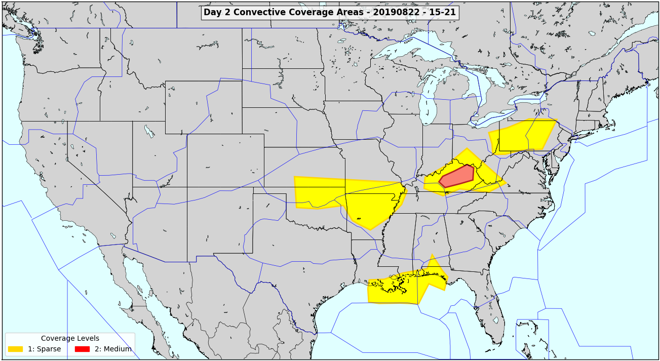
Participants generated convective coverage forecasts over 6 hr windows (09-15z, 15-21z, 21-03z, 03-09z) during the Day 2 period. These forecasts depict areas of high confidence in convective coverage areas in the same manner as current standard TCF forecasts, communicating threat areas for strategic planning to focus on for the Day 2 period. Participants have provided positive feedback for these forecast products, indicating that they have potential to provide useful information for planning at extended ranges. During the week, emphasis has been placed on the importance of consistent forecast messaging between a Day 2 and a Day 1 product.

Participant generated convective coverage forecast graphic

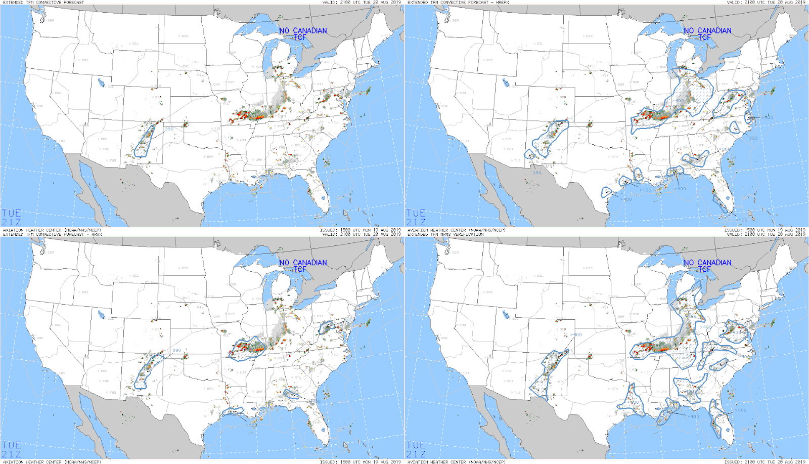
In terms of automated guidance, participants evaluated two automated products currently produced at the Aviation Weather Center (AWC) for extended range convection. Comparisons were made between the Extended Convective Forecast Product (ECFP), which shows convective probabilities over a 6 hour window, and the Extended Traffic Flow Management Convective Forecast (eTCF), which displays a convective coverage forecast at 2 hour snapshots. Participants have found that the eTCF provided more useful guidance in the Day 2 period compared to the ECFP, as the inclusion of convection allowing model (CAM) guidance in the eTCF allows for greater detail in the evolution and timing of convection.

Comparison of operational and variant eTCF forecasts (upper left, upper right, lower left) with observations (lower right)

Additionally, participants evaluated two experimental variants of the operational eTCF, which is created through a blend of models which include convection parameterization and CAM guidance. Both variants were comprised of a blend of solely CAM guidance and have performed better than the operational eTCF in both subjective and objective evaluations. The improved performance of the variants can be attributed to the ability of the CAM guidance to better forecast the evolution and timing of convective processes. Based on these results, a potential upgrade to the operational eTCF will be explored in the near future.    

Thursday, August 22, 2019

AWDE Services Gathering GA Pilot Feedback


In addition to having members of the Aviation Weather Demonstration and Evaluation (AWDE) Services team in house at the AWT providing support during the week, they were also in full experimental mode at the FAA WJHTC in Atlantic City.  They conducted user evaluations, with general aviation pilot participants, to provide feedback concerning the new capabilities incorporated into the HEMS and GFA products.  Pilots attended the lab both in person and via Webex to provide their valuable feedback.
Overall, participants gave positive feedback concerning the new capabilities such as the expanded coverage and resolution over the expanded areas, the Map Options dialog, and additional MESONET observations.  The additional capabilities and information will help inform critical decision making.


The AWT also welcomed a few pilots that participated in one-on-one interviews with AWDE personnel.  AWDE staff asked them questions about the usability of the tools, how the new capabilities added value and what changes or requests they had for the tools in general.  Overall the pilots were pleased with the current products and proposed upgrades, but expressed the need for more user-friendly capabilities.  This includes making the products easier to navigate on a mobile device as well as the addition of contextual help on the tools.  Having capabilities and weather information explained in a way that users can clearly understand is extremely important as AWC continues to evolve their products to serve the greater aviation community.


Wednesday, August 21, 2019

Evaluating 3D Cloud Guidance

One of the focus areas for this year's experiment is evaluating three-dimensional cloud model guidance.  Participants are assessing current post-processing algorithms of cloud layers and the added benefits of experimental visualization capabilities.  In order to complete the evaluation and carefully assess the different guidance products available, the participants have been tasked with creating a detailed text forecast for five specific hours: 15Z, 18Z, 0Z, 9Z, and 12Z the next day.


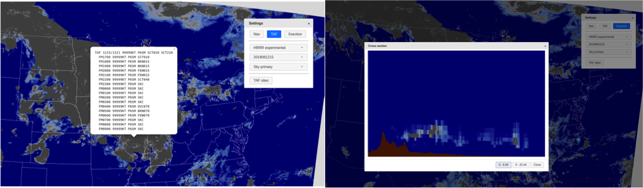
In order to get a better visualization of the 3D cloud information, AWT developed a web interface that allows for better interrogation of the data.  The web interface displays the post-processed gridded output from various model guidance options including three cloud bases and corresponding sky coverage for each forecast hour from the the latest several model runs, as well as the model derived ceiling and visibility.  In addition to the single layer look at the information, the tool allows for creating point-and-click TAFs as well as cross-sections of the cloud layer information along a path.


Along with the descriptive cloud forecasts, the participants will be answering questions about the performance of the various guidance products, any notable strengths or weaknesses, and any biases identified as well.  The various guidance products available include experimental versions of the HRRR and RAP models, the NAM and NAM Nest, and the HIRES ARW, MEM2, and the NMMB.  The experimental 3D RTMA is also available for use as a cloud layer analysis for verification purposes. 


After day one, it was clear that the cross-section ability has several advantages and could be useful for multiple users. While it may not be the primary tool used to forecast ceilings, they could prove beneficial to bolster confidence in a cloud layer occurring or in seeing a thin low cloud deck or fog.  Forecasters may not have the time to look through multiple cross sections for multiple forecast hours, however they could use it to confirm a secondary layer or get a better idea of what the model is trying to tell them in terms of the cloud development.  However, pilots may find the tool extremely useful for planning along a flight path, especially if there could be a time element added in which conditions match the time in which they expect to be flying through that region.

In terms of model performance thus far, participants have been impressed with the HRRRx cloud placement in the vertical more accurately hitting the cloud bases and coverage.  This verified well on Day 1 with the stratus off the coast of California and cloud placement in the north east associated with late afternoon convection.  Overall, so far it seems the guidance tends to agree with cloud occurrence and conditions, but differ on timing and placement.

The experimental HRRR cloud base primary indicating low ceiling moving into the Sacramento valley via the delta breeze. 


Evaluations will continue through the week with specific areas of focus being determined each morning based on impacts for that day and the next.


Tuesday, August 20, 2019

Day 1 of the 2019 AWT Summer Experiment


The 2019 AWT Summer Experiment kicked off on Monday with a full house of collaborators and stakeholders from multiple entities of the aviation weather enterprise. Participants include developers from NOAA’s Earth System Research Lab (ESRL), NWS’s Meteorological Development Lab (MDL), and NCEP’s Environmental Modeling Center (EMC); meteorologists from each NWS region including Alaska and Hawaii, Deutscher Wetterdienst (German weather agency), and Southwest Airlines; as well as stakeholders from NWS headquarters, the US Air Force 557th Weather Wing and the FAA’s Aviation Weather Research Program (AWRP).


There are three major themes that will be explored throughout the week. The first is an evaluation of new features and capabilities in the Graphical Forecasts for Aviation (GFA) and Helicopter Emergency Medical Services (HEMS) web tools.


The Graphical Forecasts for Aviation (GFA) was recently expanded operationally to include the western Atlantic, Gulf of Mexico, and Caribbean Sea in order to give end-users graphical alternatives to the current text-based Area Forecasts still issued for that region. The AWT is also demonstrating additional geographical expansions over much of the Pacific, including Hawaii, and north into Alaska where user feedback will be critical. AWC will be updating the gridded ceiling and visibility (C&V) analysis in the HEMS tool this coming spring and is seeking user feedback on this, as well as some other potential updates to the tool, during the week long experiment.


In addition to the meteorologists and developers on hand to evaluate these updated web tools, pilots will be attending the AWT in person and remotely to provide feedback to human factors experts from the FAA Aviation Weather Demonstration and Evaluation (AWDE) services group. This feedback is critical to ensuring AWC's products continue to evolve to meet the needs of the users most dependent on them.


The second area of focus for the week will be evaluating new cloud layer guidance derived from numerical model 3-D cloud information. Participants will be given the task to create a forecast for cloud evolution over an area with expected aviation impacts. They will have various visualization tools to use in order to examine the 3D cloud information including a point-and-click TAF capability and a point to point cloud cross section viewer. The goal is to have an evaluation of the guidance itself to better tailor post-processing and tooling, as well as how 3D cloud information can be used to improve aviation forecasts in the future.


Finally, AWT participants will be looking at potential extended-range convective guidance products. National traffic planning is increasingly looking at the next day and beyond to better get ahead of potential impacts before they start affecting the NAS, and determining the best path forward in how to present this information to all stakeholders involved is critical.

Stay tuned for updates throughout the week and early findings from each desk!

Thursday, August 15, 2019

Aviation Weather Testbed Summer Experiment 2019

The 2019 Aviation Weather Testbed (AWT) Summer Experiment will be held at the Aviation Weather Center (AWC) in Kansas City next week! There are three major themes that will be explored throughout the experiment: (1) an evaluation of new features and domain expansion of the Graphical Forecasts for Aviation (GFA) and the Helicopter Emergency Medical Services (HEMS) tool, (2) an evaluation of new cloud layer guidance derived from numerical model 3-D cloud information, (3) and an evaluation of extended range impact-based convective forecasting. Stay tuned for more updates and exciting details from the week.


Tuesday, September 25, 2018

Evaluating Guidance for Planning Day 1 and Beyond

The Aviation Weather Center (AWC) does not currently produce a Day1, or longer, outlook for aviation planning.  One of the goals of this experiment was to evaluate guidance and the capability to produce a Day 1, as well as a Day 2-4 outlook for planning purposes.  What these products would look like and entail is still very much in the early stages.


The goal of the Day 1 product is to target extreme turbulence broken up into four categories; Marginal, Slight, Moderate, and High.  The Moderate and High categories would indicate areas where a SIGMET is most likely, with the greatest certainty contained in the High coverage areas.  The graphic above is an example of what this product could look like.  When it would be issued, and the audience of such a product still needs to be discussed at length.  Along with the graphic, an accompanying text product, or discussion explaining the coverage areas and reasoning may also be beneficial.

Guidance evaluated for this product included the operational "Graphical Turbulence Guidance", or the GTG, RAP GTG, and the FV3 GTG.  The operational and RAP GTG were very similar in signal, with the RAP version having hourly forecasts out to f21, which is very useful for planning in the extended period.  Noticeable differences were seen when comparing the GFS GTG and the FV3 GTG, with FV3 showing stronger signals over GFS.  An example is shown below, with FV3 in the top left and GFS on the bottom right.


The extended out, looking at Day2-4 would be focused on several phenomena that could have high impacts on flight planning.  These include snow, thunderstorms, winds, wind compression, low ceilings and visibilities, sleet/freezing rain, turbulence, and en-route icing.  This product would likely focus on weather activity affecting the core 30 airports to support NAM operations and PERTI outlooks.


In addition to making the outlook product, participants compared the new FV3 variables with GFS, to see if they were consistent.  Visibility in FV3 seemed to be more concentrated showing lower visibilities and less coverage when compared to the GFS.  The convective and icing fields showed similar outputs between the two models, with FV3 tending toward slightly higher intensities of icing.


When it came to creating the product, there was a difference observed in how the NAM particpant would create the forecast versus a forecaster from AWC.  The NAMs are very focused on  high impacts to the core 30 airports, and thus tended to make a quicker product with less model interrogation.  Whereas the AWC meteorologists tended to focus on all possible weather hazards regardless of specific airports providing more structured commentary and taking a longer time to produce the product overall.

The development of both products is still in the very early stages.  A lot more discussion and demonstration needs to take place before it would be looked at as a possible operational product.  However, the feedback received this week was a giant step in the forward direction to seeing how such a product would be beneficial for users at all levels. 


Monday, September 24, 2018

No Stratus, No Problems

Another focus of the experiment this summer was looking at high-resolution ceiling and visibility (C&V) model data over the San Francisco airport (SFO).  The airport utilizes a parallel runway system that requires pilots to be able to physically see each other as they make their landing approach.  When low ceilings are present (< 3000ft), the use of parallel approaches is restricted, causing decreased arrival capacity and increased delays. 

The UK Met Office and the ESRL Global Systems Division (GSD) HRRR group both provided high-resolution nests over SFO for this experiment.  The UK Met model nest has 330m grid spacing, with the experimental HRRR nest set at 750m horizontal grid spacing. 

As luck would have it, during the week of the experiment SFO was stratus free!  So instead, participants kept busy by looking at how the various model guidance handled the clouds and other phenomena in the area within the nests.  Focus was also given to Monterrey bay some days, which is just south of SFO.  In addition to the high-resolution nests from the UK Met model and the HRRR, participants also compared with experimental versions of the LAMP and RTMA.


In the above example, the HRRR 750m nest looks to best represent the cloud structure seen in the GOES 17 imagery west of Monterrey bay.  Another example below shows how the HRRR experimental starts to clear out the cloud cover inland of the bay by 15Z, where the experimental RTMA 3-D continues to keep the clouds at 15Z, which is later verified by satellite imagery.


In addition to clouds from the models, participants also looked at winds, the NDFD sky cover and how it compared to the guidance, as well as how RTMA and LAMP interpret observations into their analysis and forecasts.  So even without stratus, valuable information on the various guidance products was gained.

Thankfully, partners at both GSD and the UK Met office have agreed to continue producing the experimental nest data for a few more weeks so that AWC researchers can continue to evaluate the data when stratus is in fact present over SFO.